Scale (Zoom) Dependent Maps with Leaflet in R
geography
mapping
R
programming
data-science
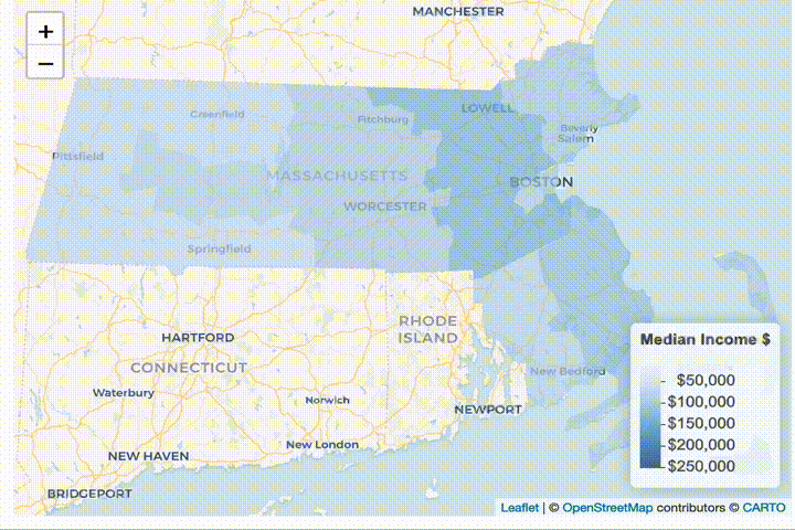
Something I’ve wanted to accomplish for a while is producing interactive maps in R that provide a higher level of resolution as the user zooms in.
I’ve finally sat down and accomplished that, and I’m quite happy to be sharing the R code here.
Since I live in the Boston area and have family in the New York area, I thought those were great examples to start with, but the code should be easily adaptable to any US state or locale that has data collected in the American Community Survey.
# dependencies
require(leaflet)
require(sf)
library(tidycensus)
library(tidyverse)
library(tidyr)
library(magrittr)
library(leafpop)
library(htmlwidgets)
library(leaflet.extras)

options(tigris_use_cache = TRUE)
# median income, age, and pct in poverty in Boston Area ---------------------------------------------------
# download county data
ma_counties <- get_acs(
geography = "county",
state = "MA",
variables = c(
median_income = "B19013_001",
median_age = "B01002_001",
total_for_poverty = "B17101_001",
in_poverty = "B17101_002"
),
year = 2021,
geometry = FALSE
)
# download tract data
ma_tracts <- get_acs(
geography = "tract",
state = "MA",
variables = c(
median_income = "B19013_001",
median_age = "B01002_001",
total_for_poverty = "B17101_001",
in_poverty = "B17101_002"
),
year = 2021,
geometry = FALSE
)
# download block group data
ma_block_groups <- get_acs(
geography = "block group",
state = "MA",
variables = c(
median_income = "B19013_001",
median_age = "B01002_001",
total_for_poverty = "B17101_001",
in_poverty = "B17101_002"
),
year = 2021,
geometry = FALSE
)
# put the data together in a list
ma_geographic_dfs <- list(
counties = ma_counties,
tracts = ma_tracts,
block_groups = ma_block_groups
)
# pivot the data wider
ma_geographic_dfs %<>% purrr::map( ~ tidyr::pivot_wider(
.,
id_cols = c('GEOID', 'NAME'),
names_from = 'variable',
values_from = 'estimate'
))
# calculate the pct in poverty from last 12 months of household income poverty threshold data
ma_geographic_dfs %<>% purrr::map( ~ mutate(., pct_in_poverty = in_poverty / total_for_poverty * 100))
# add geography data to each:
# we held off on doing this in the `tidycensus::get_acs` calls because sf objects
# often interact poorly with `tidyr::pivot_wider`
ma_geographic_dfs$counties <-
left_join(
tigris::counties(
cb = TRUE,
resolution = '20m',
state = 'MA'
),
ma_geographic_dfs$counties,
by = c('GEOID' = 'GEOID')
)
ma_geographic_dfs$tracts <-
left_join(
tigris::tracts(cb = TRUE, state = 'MA'),
ma_geographic_dfs$tracts,
by = c('GEOID' = 'GEOID')
)
ma_geographic_dfs$block_groups <-
left_join(
tigris::block_groups(cb = TRUE, state = 'MA'),
ma_geographic_dfs$block_groups,
by = c('GEOID' = 'GEOID')
)
# this formatter is so that the data we show in the `leafpop::popupTable` renders nicely
custom_formatter <- function(df) {
# use the scales::*_format functions to provide nice formatting
df$median_income %<>% scales::dollar_format()()
df$median_age %<>% scales::number_format()()
df$pct_in_poverty %<>% scales::percent_format(scale = 1, accuracy = .1)()
# we don't want to be sending lists of boundary coordinates into the popupTable
df %<>% sf::st_drop_geometry()
# some quick renaming & selection of only important variables
df %<>% select(
GEOID,
NAME = NAME.y,
`Median Age` = median_age,
`Median Income` = median_income,
`Poverty` = pct_in_poverty
)
return(df)
}
# we'll use Blues for the income level
income_pal <- colorNumeric("Blues", domain = ma_geographic_dfs$block_groups$median_income, na.color = NA)
leaflet() %>%
addProviderTiles(providers$CartoDB.Voyager) %>%
addPolygons(
data = ma_geographic_dfs$counties,
fillColor = ~income_pal(median_income),
weight = 0,
color = "white",
fillOpacity = 0.7,
group = 'counties',
popup = leafpop::popupTable(custom_formatter(ma_geographic_dfs$counties), row.numbers = F)) %>%
addPolygons(
data = ma_geographic_dfs$tracts,
fillColor = ~income_pal(median_income),
weight = 0,
color = "white",
fillOpacity = 0.7,
group = 'tracts',
popup = leafpop::popupTable(custom_formatter(ma_geographic_dfs$tracts), row.numbers = F)) %>%
addPolygons(
data = ma_geographic_dfs$block_groups,
fillColor = ~income_pal(median_income),
weight = 0,
color = "white",
fillOpacity = 0.7,
group = 'block groups',
popup = leafpop::popupTable(custom_formatter(ma_geographic_dfs$block_groups), row.numbers = F)) %>%
addLegend(
data = ma_geographic_dfs$block_groups,
pal = income_pal,
values = ~median_income,
opacity = 0.7,
title = "Median Income $",
labFormat = labelFormat(prefix="$"),
position = "bottomright"
) %>%
addFullscreenControl() %>%
groupOptions("block groups", zoomLevels = 13:20) %>% # this is where the magic (scale/zoom dependent rendering happens)
groupOptions("tracts", zoomLevels = 10:12) %>%
groupOptions("counties", zoomLevels = 1:9) ->
ma_income_map
htmlwidgets::saveWidget(ma_income_map, file = "ma_income_map.html", selfcontained = FALSE)poverty_pal <- colorNumeric("Reds", domain = ma_geographic_dfs$block_groups$pct_in_poverty, na.color = NA)
leaflet() %>%
addProviderTiles(providers$CartoDB.Voyager) %>%
addPolygons(
data = ma_geographic_dfs$counties,
fillColor = ~poverty_pal(pct_in_poverty),
weight = 0,
color = "white",
fillOpacity = 0.7,
group = 'counties',
popup = leafpop::popupTable(custom_formatter(ma_geographic_dfs$counties), row.numbers = F)) %>%
addPolygons(
data = ma_geographic_dfs$tracts,
fillColor = ~poverty_pal(pct_in_poverty),
weight = 0,
color = "white",
fillOpacity = 0.7,
group = 'tracts',
popup = leafpop::popupTable(custom_formatter(ma_geographic_dfs$tracts), row.numbers = F)) %>%
addPolygons(
data = ma_geographic_dfs$block_groups,
fillColor = ~poverty_pal(pct_in_poverty),
weight = 0,
color = "white",
fillOpacity = 0.7,
group = 'block groups',
popup = leafpop::popupTable(custom_formatter(ma_geographic_dfs$block_groups), row.numbers = F)) %>%
addLegend(
data = ma_geographic_dfs$block_groups,
pal = poverty_pal,
values = ~pct_in_poverty,
opacity = 0.7,
title = "% in Poverty",
labFormat = labelFormat(suffix="%"),
position = "bottomright"
) %>%
addFullscreenControl() %>%
groupOptions("block groups", zoomLevels = 13:20) %>%
groupOptions("tracts", zoomLevels = 10:12) %>%
groupOptions("counties", zoomLevels = 1:9) ->
ma_poverty_map
htmlwidgets::saveWidget(ma_poverty_map, file = "ma_poverty_map.html", selfcontained = FALSE)age_pal <- colorNumeric("magma", domain = ma_geographic_dfs$block_groups$median_age, na.color = NA, reverse = TRUE)
leaflet() %>%
addProviderTiles(providers$CartoDB.Voyager) %>%
addPolygons(
data = ma_geographic_dfs$counties,
fillColor = ~age_pal(median_age),
weight = 0,
color = "white",
fillOpacity = 0.7,
group = 'counties',
popup = leafpop::popupTable(custom_formatter(ma_geographic_dfs$counties), row.numbers = F)) %>%
addPolygons(
data = ma_geographic_dfs$tracts,
fillColor = ~age_pal(median_age),
weight = 0,
color = "white",
fillOpacity = 0.7,
group = 'tracts',
popup = leafpop::popupTable(custom_formatter(ma_geographic_dfs$tracts), row.numbers = F)) %>%
addPolygons(
data = ma_geographic_dfs$block_groups,
fillColor = ~age_pal(median_age),
weight = 0,
color = "white",
fillOpacity = 0.7,
group = 'block groups',
popup = leafpop::popupTable(custom_formatter(ma_geographic_dfs$block_groups), row.numbers = F)) %>%
addLegend(
data = ma_geographic_dfs$block_groups,
pal = age_pal,
values = ~median_age,
opacity = 0.7,
title = "Median Age",
position = "bottomright"
) %>%
addFullscreenControl() %>%
groupOptions("block groups", zoomLevels = 13:20) %>%
groupOptions("tracts", zoomLevels = 10:12) %>%
groupOptions("counties", zoomLevels = 1:9) ->
ma_age_map
htmlwidgets::saveWidget(ma_age_map, file = "ma_age_map.html", selfcontained = FALSE)